MS Thesis Defense: Muhammad Ahmed Bhimra

Spatio-Temporal Analysis of Landuse-Landcover Change Using Satellite Imagery
Thursday 28 Feb, 2019 at 10:00 am in Smart Room 9-105 SBASSE.
Abstract
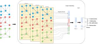
We propose an approach to recognize large scale, rapid spatio-temporal analysis of satellite remote sensing data. This technique can be used to measure longitudinal changes and yearly changes. Most of the existing methods either look for changes in annotations over the years or run classification of several years separately and then evaluate changes. The problem with these approaches is that they are classifying spatial and temporal features separately, and might lose some important information. In this paper, We have proposed a 3D Convolutional Neural Network (CNN) based on the ResNet architecture that takes a 3D spatio-temporal block comprising of x and y dimension of an image as well as time, as third dimension. Extensive experimental results have shown that the proposed method outperforms state-of-the-art methods by a large margin. We also provided dataset and annotation for four key spatio-temporal classes.
Project Pages:


