
VillageFinder: Segmentation of Nucleated Villages in Satellite Imagery
Kashif Murtaza, Sohaib Khan, Nasir Rajpoot
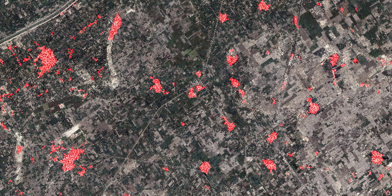
50 sq km image of rural area, with village outpus marked in red. 2.3% false positives at 0.01% false negatives
[high res version 30MB JPG]
Abstract
Geo-spatial data on village locations, their size, population and other parameters is scarcely available to decision makers in many developing countries. In this paper, we demonstrate an automatic “crawler” which can segment nucleated villages from satellite imagery freely available in public domain geographic information systems such as Google Earth. Our approach is to use frequency and color features to generate a number of weak classifiers, which are then combined through Adaboost to produce the final classifier. We use a total of 69 features in the generation of the weak classifiers, including phase gradients, cornerness measures and color features. Our primary dataset consists of 60 images having more than 345 million pixels and covering more than 100 sq km of area, containing nucleated villages in fifteen countries, spread over four continents and captured by different sensors. Using six manual annotations for ground-truth, we perform five-fold cross validation, using 25% of data for testing. Our results show an Equal Error Rate (EER) of around 3.4%. Using the trained classifier, we detect villages on a 50 sq. km image (close to 184 million pixels) from a different site than the images used in training, and demonstrate highly accurate extraction of villages with 2.3% false positives and 0.01% false negatives.
Downloads
- BMVC’09 paper [7.5 MB PDF]
- BMVC’09 one page summary [630 KB PDF]
- BMVC’09 poster [3.2 MB PDF]
- Code and Datasets(All in one)[339 MB] used in the paper
Dataset
| Primary Dataset | 60 images captured from Google Earth [Original Images][Observer Variance Data][Ground Truth (individual)][Ground Truth(fused)][Results Binary][Results Overlayed][Training Images] |
| Secondary Dataset | Single image (50 sq km) [Original Image][GroundTruth Binary][GroundTruth Overlayed][Results Binary][Results Overlayed] |

