Water Quality Assessment Using Visual Sensors

Water Quality Assessment Using Visual Sensors

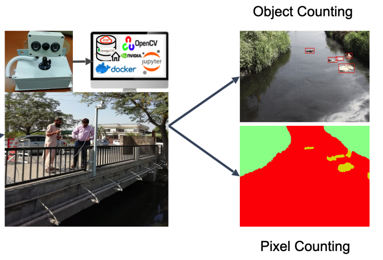
Mohbat Tharani, Abdul Wahab Amin, Fezan Rasool, Muhammad Maaz, Murtaza Taj, Abubakr Muhammad Summary In the absence of an effective trash management framework, trash is often illegally dumped in rivers and canals running through urban areas, contaminating freshwater and blocking drainage lines which result in urban floods. When this contaminated water reaches agricultural fields, it…

5xMS Thesis Proposal Defence

Tuberculosis Diagnosis in Medical Imagery using Deep Learning by Inam Ullah Taj Estimating labor population in Brick Kilns using Satellite Imagery and Remote Sensing by Muhammad Awais Ather Compressing neural networks via teacher assisted learning by Umair Haider Online structured filter pruning for neural networks by Shaiq Munir Malik Semantic Segmentation of water channel to…

BMVC 2009 – VillageFinder: Segmentation of Nucleated Villages in Satellite Imagery
|

BMVC 2009 – VillageFinder: Segmentation of Nucleated Villages in Satellite Imagery

Kashif Murtaza, Sohaib Khan, Nasir Rajpoot British Machine Vision Conference (BMVC), September 2009 Abstract Geo-spatial data on village locations, their size, population and other parameters is scarcely available to decision makers in many developing countries. In this paper, we demonstrate an automatic “crawler” which can segment nucleated villages from satellite imagery freely available in public…